Olivier Moly photographer, dreamer, adventurer…

Archive for ‘February, 2013’

20130223_0040To see all of the pictures click on the picture above.

To follow my route follow this link.

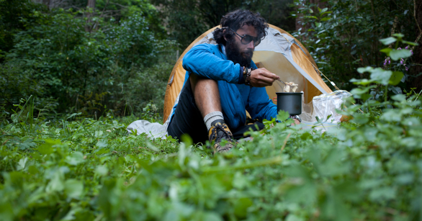
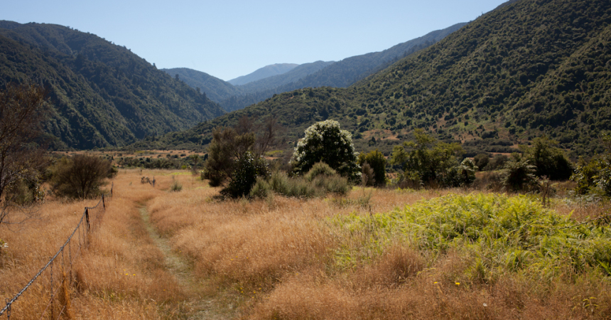
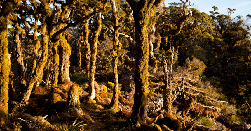
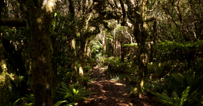
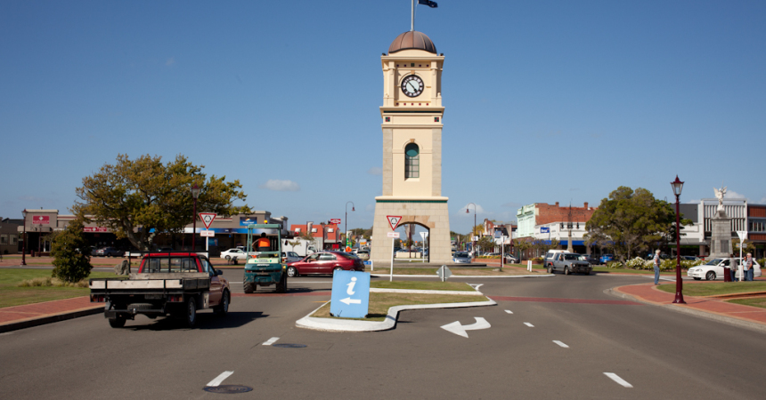
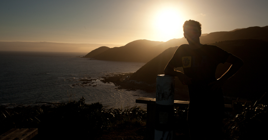
Thirty kilometres to walk today to reach the end of the track on the North Island. While I was having my morning tea I met Rod a Te Araroa walker I had met in Pipiriki, we talked a bit and he went back on his adventure. I packed my backpack and left for my last day walking the Te Araroa in the North Island. I walked on this road surrounding by horse stables, I believed it was a well known area for horse riding and breeding. The road finished on a farm track called the old coach track leading to a saddle where a beautiful text sites on a rock beside a bench overlooking hills and farm lands. The track led me to the Mount Kaukau a beautiful lookout on Wellington. I kept going on these windy hills reaching the suburb. I finally reached Wellington, but it wasn’t finished, I had to go to Island Bay my last destination. I walked through the botanic garden and called my friend Ben, he met me 20 minutes later. It has been a while I didn’t see him, one my best mate from High school, hiking the Te Araroa with me for the last 10 kilometres. I was just so happy, I couldn’t tell. Walking, talking, laughing we were having a great time, when a new surprise was waiting not far from us. Limping, up on the hill I saw a familiar silhouette, Laura my friend from Kentucky. We were just so surprised to run into each other without being aware. We kept going with Ben and left Laura behind us, we will see her later for a drink. The track was undulating as hell and we got to the end late on the evening greeting by a beautiful sunset.
I will spend one week in Wellington to resole my shoes and maybe to extend my VISA. 1624 kilometres covered, I need a good rest and I really want to enjoy Wellington known for its cool atmosphere. I just want to enjoy a latte in terrace with my friends.

Plus que 30 kilomètres à parcourir et je met fin à la traversé de l’île du Nord. J’étais en train de déguster mon thé, quand j’ai rencontré Rod. Je l’ai dèjá croisé à Pipiriki et je pensais qu’il était loin devant moi. Il fait marche sur la Te Araroa mais lui a commencé à Auckland et son point de chute est à Wellington. Nous partageons quelques mots puis il reprend la route. Je fais mon sac et à mon tour retourne pour ma dernière journée sur l’île du Nord. Je quitte la forêt Spicer et arrive sur une route passant par de nombreuses écuries, je suppose que cet région doit être réputée pour l’élevage de chevaux, c’est assez étonnant car chaque propriété dispose d’une écurie. La route se termine sur un sentier nommé Old Coach Road qui me mène à un col où un texte plein d’émotion est encastré dans un rocher près d’un banc dominant une vue magnifique sur les collines environnantes. Quelques de marche plus tard, je peux admirer Wellington du haut du mont Kaukau. Je continue cette dernière balade bousculé par le vent pour enfin arrivé dans la banlieue de Wellington. Ce n’est pas encore terminé, je dois maintenant atteindre Island Bay qui se trouve à une bonne vingtaine de kilomètres. Je passe par le jardin botanique et passe un coup de fil après avoir rechargé mon téléphone à Ben un ami du lycée que je n’ai pas vu depuis longtemps. La dernière que je l’ai vue nous étions à Melbourne. Il me rejoint pour finir le sentier, c’est tellement bon de le revoir, tellement incroyable de le voir ici. Nous marchons à bonne allure, traversant parc et rues. Nous perdons le chemin parfois qui n’est pas parfaitement balisé et puis je vous avoue ne pas être concentré sur notre progression, nous tant à nous raconter et ça fait si longtemps que je n’ai pas parlé en français. En chemin nous tombons par hasard sur Laura, que j’aperçois boitant à un arrêt de bus, c’est une amie que j’ai rencontré à Auckland. Quelle chance de la trouver là, elle ne nous accompagne pas, mais nous la retrouverons ce soir pour un verre certainement. Nous continuons notre bonhomme de chemin avec Ben et arrivons vers 8 heure sur Island Bay accueilli par un magnifique coucher de soleil. Je dois faire ressemeler mes chaussures et essayer de renouveler mon VISA sur Wellington. Je vais donc passer une semaine ici et puis je mérite bien une bonne pause après ces 1624 kilomètres parcourus. Wellington est une ville comme je les aime, remplie de petits cafés et magasins à l’atmosphère artistique. Il me tarde seulement d’être assis avec mes copains autour d’un café latte.

1 Comment

20130222_0103To see all of the pictures click on the picture above.

To follow my route follow this link.

In my head, the day before walking with someone and not even a guy doing the Te Araroa was like a dream, weird to believe that I walked twenty kilometres with Louis. I left Paekakariki and walk on a footpath beside the narrowest part of the SH1, not enjoyable but having the Tasman Sea on my right side made me forget cars and trucks. I got to a bunch of houses on Ocean Parade a nice little beach village and took the Goat Track going steeply up hill. Then I kept following the SH1 by a nice paved walkway going along the Taupo Swamp an old place where flax was harvesting to make ropes and other fabrics. I passed through Porirua and reached the Colonial Knob where the wind was so strong pushing me helping me going up hill. I didn’t stay too long it was really cold and went back to the forest where I found a nice spot near a stream to pitch my tent.

Le souvenir d’avoir marché avec Louis pendant une journée entière me semblait comme un rêve, juste le fruit de mon imagination tant cela a été improbable. Je quitte le camping de Paekakariki et emprunte un trottoir longeant une des parties les plus étroites de la Nationale 1. Pas très agréable de marcher entre un mur et ces voitures lancées à plus de 100 kilomètres à l’heure, par chance la vue sur la mer de Tasman est magnifique. Ce long calvaire prend fin et ce n’est pas trop tôt quand j’atteint un petit hameau sur le bord de mer, personne n’est là tout est enfin calme. J’arpente le chemin des chèvres qui m’amène au dessus de la falaise pour suivre à nouveau la Nationale 1 mais par un tout autre chemin beaucoup plus calme traversant le marée de Taupo. Ce marée fut l’un des endroits les plus connu pour la récolte du “Harakeke” ou Lin de Nouvelle-Zélande, il servait à la confection de corde et tissu. Arrivé sur Porirua, je me dirige vers le mont Colonial, le vent me pousse facilitant mon ascension. Je suis sur le point d’arriver quand le vent se déchaine coupé de toute barrière naturel, je me fais balloter dans tout les sens comme un hochet au prise d’un gamin. La vue est magnifique, je reste quelque temps en plein vent profitant de ce qui ne sera plus et redescend dans la forêt Spicer. Je me trouve un petit coin pour planter ma tente sur le bord d’un ruisseau en bordure de chemin, ma dernière nuit avant d’arrivée sur Wellington si tout va bien.

Leave a comment

20130221_0050To see all of the pictures click on the picture above.

To follow my route follow this link.

Louis woke up at the same time as me this morning, it was his day off and asked me if he could join me to walk to Paekakariki, I accepted for sure it’s great to have a hiking mate. Louis is this unusual character who used to live during nine months in the bush building his own hut, having a huge knowledge about native birds and plants. He works at Nga Manu Nature Reserve in Waikanae which is a bird sanctuary and they have a breeding program for the species endangered. We got along really well, on our way following the river he showed me what kind of plants are edible and told stories about Kapiti Island and places we walked through. He lived here a big part of his life and knows everything about this area. We walked on the beach, starring at shags and oyster-catchers, we had beers, smoothies, thick-shakes and burgers. This day was just really random, it was like we knew each other since ages. We finally got to Paekakariki and had a last burger and beer. Louis took the train back home and I stayed at the motor camp. A bit sad to see him leaving, knowing it will be difficult to catch with him as he doesn’t fit with Internet and phones.

Louis se réveille en même temps que moi et me demande où je dois aller aujourd’hui. Il se propose de m’accompagner jusqu’à Paekakariki, c’est son jour de repos aujourd’hui et son père vit là-bas et ça fait longtemps qu’il voulait lui rendre visite. Louis est un de ces gars original qui a vécu dans le bush pendant 9 mois sous un abris qu’il a construit de ses mains, il travaille dans la réserve naturelle Nga Manu à Waikanae. Il s’agit d’un programme d’élevage d’espèces natives et endémiques protégées pour repeupler les forêts natives de Nouvelle-Zélande. Il en connait un rayon sur tout ce qui est plante et oiseau, nous suivons la rivière Waikanae et il me montre qu’elle sont les plantes que je peux consommer et la façon de les préparer. Nous approchons de la plage, l’île Kapiti se dresse devant tout comme sortie du néant, Louis me parle des histoires de l’île. C’est maintenant devenue une réserve naturelle, elle était il y a bien longtemps l’île d’un puissant chef Maori qui tua de nombreux colons, un des marécages sur l’île serait apparemment rempli de cadavres. Louis a vécu ici la plus grande partie de sa vie, il a exactement le même âge que moi. Il me montre la maison où il a grandit et me parle de tout ces endroits qu’il a vu changer au fil des années. Nous marchons sur la plage, nous arrêtant parfois pour un milk shake ou une bière, observant les cormorans et les huîtriers et admirant le bleu azuré de la mer Tasman. C’est bon d’avoir un compagnon de marche, le plus drôle c’est que je ne me serais jamais attendu à ce que quelqu’un que je ne connais pas m’offre de me suivre pour une journée. Nous arrivons enfin à Paekakariki où j’établis mon camp dans le camping en bord de ville. Nous partons ensuite dans le centre, son père n’est pas là et nous décidons de nous faire un hamburger avant qu’il ne retourne chez lui en train. Ce fut une belle rencontre, je ne sais pas si je le reverrais puisqu’il n’est pas vraiment téléphone et Internet, néanmoins j’en garderai un souvenir inaltérable.

Leave a comment

20130220_0016To see all of the pictures click on the picture above.

To follow my route follow this link.

I left around 7 am saying goodbye to Mike and Jonathan. I had to hike 30 kilometres this day with 1000 metres elevation up, something I wasn’t afraid of but I knew it would not easy. I left the Tararua Range finally reaching the Otaki Forks about 12 pm then kept going on a track climbing steadily to the Pukeatua Summit. There I could admire the Tararua Range and the Kapiti island, it’s amazing to be able to see what you’ve done before and drawing your route line. I finally reached Mangaone South Road that led me to Waikanae. Exhausted, I went to the pub to ask for a room but it was fully booked. I wandered in the street calling motel and backpacker around but everything was really expensive or booked. While I was walking a guy stopped me asking what I was up to. I told him my all story, Louis offered me a rum coca and we started to talk, he shared his take-away with me and offered me to stay in his caravan. I finally found a place to stay for the night tiny but it was better than sleeping in the street.

Réveillé par Mike et Jonathan, j’ai réussi à partir aux alentours de 7 heure après leur avoir fait mes adieux. J’ai 30 kilomètres à faire aujourd’hui avec plus de 1000 mètres de dénivelé pour rejoindre Waikanae la prochaine ville sur le sentier. Je sais pertinemment que cela ne va pas être facile, mais le seul fait de commencer à sept heure me donne plus de chance d’y venir à bout. Après 400 mètres d’ascension à travers la forêt, je descend enfin vers la rivière Otaki et sors des Tararuas aux environs de midi. J’emprunte alors un sentier dans raide dans un premier temps puis montant vers le sommet Pukeatua progressivement. Me voici enfin sur le sommet au bout de mes peines dominant les environs, je peux admirer l’île Kapiti, les Tararuas et avoir une idée du chemin parcourut. Je n’ai plus qu’a descendre vers la route Mangaone South et la suivre jusqu’à Waikanae, un bon 20 kilomètre m’attende. Enfin arrivé et épuisé, il est 8 heure du soir et je m’attèle à trouver un endroit pour dormir, tout est trop cher, trop loin ou complet. Je me met à errer dans les rues et rencontre Louis qui m’offre un rhum-coca. Nous discutons des heures sur une petite place au milieu du village et il partage son diner avec moi. Voyant que je suis fatigué et dépourvu d’idée pour dormir, il m’offre de dormir dans sa caravane sur le canapé. J’accepte, c’est un bon gars et j’ai appris dans mon voyage à jauger les gens, je ne crains rien avec lui. J’ai finalement trouvé un endroit où crécher, c’est une peu petit mais c’est mieux que rien.

Leave a comment

20130219_0021To see all of the pictures click on the picture above.

To follow my route follow this link.

Dracophyllum hut made me feel like being in a nest, cosy tiny hut. The track undulated following the ridges above and through the forest, leading me to the Mount Crawford. The scenery was indescribable, breath taking, around me I could see all of the west coast, the Tasman Sea, Mount Taranaki, Mount Ruapehu, Malborough Sounds. This remind me how we are so ridiculously tiny and insignificant. I took a deep breath and stayed standing up facing this for some minutes trying to catch every single image to keep it somewhere in my mind. Difficult to realise it is impermanent and can’t last forever, just trying to enjoy those few minutes and this is over…
The mount Crawford wasn’t really far when I saw silhouettes at its top. I got to the top and one of the two people there shout at me, Mike my Te Araroa’s mate was there. He was surprised to see me there and so I was. Jonathan his brother in law was with him. To finish Mike’s journey, they were doing this summit together. Mike and Jonathan offered me to stay with them at Waitewaewae Hut and have a dinner with them which was more than welcome for me because I was running out of food. We went down to the hut chatting about our adventures and had a swim in Otaki River before getting to the Hut. Waitewaewae is a massive hut one the middle of the bush near Otaki River. Mike and Jonathan make us a memorable dinner with mashed potatoes, meat, peas and pudding. They gave me some food to last until Waikanae the next town to resupply.

Ce refuge est un petit nid douillet, tellement agréable d’avoir un abri comme celui-ci en plein milieu de nulle part. Le sentier continue d’onduler suivant les crêtes me conduisant tout droit vers le mont Crawford s’élevant à 1462 mètres d’altitude. Le paysage est à couper le souffle, la vue s’étend au loin et je peux admirer la mer Tasman, le mont Taranaki, le mont Ruapehu, le détroit des Malboroughs sur l’île du Sud. Tout cela est juste inconcevable pour mon esprit, pour observer ce genre de panorama et paysage j’ai parcouru 1500 kilomètres et me voilà récompensé par un temps magnifique et cette vue infinie. Ceci ne durera pas, seulement quelques minutes, tout est impermanent. Nous sommes tellement insignifiant…
Je continue de marcher et m’approche du mont Crawford, j’aperçois deux silhouettes, je vais enfin rencontrer des randonneurs. Presque arrivé, j’entend quelqu’un crier mon nom, je relève la tête et vois Mike mon collègue de la Te Araroa que j’ai croisé à maintes reprises. Le voilà avec son beau frère Jonathan au sommet profitant de la vue. Nous nous racontons nos aventures et quand il apprend que je n’ai presque plus de nourriture il me propose de m’en donner et de continuer le chemin avec eux pour prendre un diner tout les trois ce soir dans le prochain refuge de Waitewaewae. J’accepte sans attendre cette offre et nous voilà marchant, partageant nos aventures, éclatant de rire. C’est bon d’avoir des potes de marche, ça fait une éternité. Avant d’arriver au refuge nous nous baignons dans la rivière puis Mike et Jonathan me prépare un diner mémorable et me donne un peu de nourriture pour continuer le lendemain.

Leave a comment

20130218_0090To see all of the pictures click on the picture above.

To follow my route follow this link.

As usual sleeping in the forest is just amazing my tent was dry, which is a gain of time. The track climbed steeply following a ridge to reach the first hut Waiopehu Hut. Once there I made myself a tea with powder milk but no sugar anymore. I was starting to be worried because the track is not really easy and I don’t have enough food to spend more than three days in this Range. The track was undulating all of the way long to the Te Matawai Hut, I was at this hut around 4 pm and I wanted to reach the Dracophyllum Hut. Difficult choice I just had 4-5 hours before the night, the sky was cloudy and the next part of the track was 500 meters elevation up. I had a big cereal bowl and kept walking. The light on the ridge while I was walking was just fantastic, I could see the Tasman sea on my right and all the Tararua Range, it was gigantic. When the sun started to set I arrived at the hut, finally. The Dracophyllum Hut is a tiny hut that could fit two people not more, I was by myself so I spread out all of my gear everywhere putting a big mess around. A warm light attracted me outside, the sky this evening was red and made the illusion that the forest was catching on fire.

Comme d’habitude dormir en forêt est reposant, le bruit de la forêt, le vent dans le feuillage, les oiseaux te bercent et t’accompagnent doucement dans les bras de Morphée. Ma tente est sèche ce matin, un gain de temps et moins de poids à me trimbaler. L’ascension vers le refuge Waiopehu est raide et le chemin un peu boueux mais pas trop difficile. Arrivé au refuge je me prépare un thé, j’ai toujours du lait mais plus de sucre et je n’ai pas suffisamment de nourriture pour passer plus de trois jours avant de trouver une ville et malheureusement la prochaine ville est à 60 kilomètres avec beaucoup de dénivelé positif. Je rejoins sans moindre mal le refuge suivant Te Matawai, je me trouve maintenant à 6-7 heures de marche du refuge Dracophyllum et il ne me reste que 5 heures avant le couché du soleil. Un choix difficile à faire sachant qu’il est impossible de planter ma tente en chemin puisque trop exposé et la météo ne s’annonce pas clémente, le ciel est noir de nuages. Je me fais un gros bol de céréale pour me donner l’énergie suffisante et je me décide à reprendre la route. Je marche désormais sur une ligne de crête en direction du sommet Pukematawai 1432 mètres d’altitude, le soleil traverse les nuages noir d’encre illuminant quelques parties des Tararuas, c’est simplement spectaculaire. Je me donne comme objectif d’être sur Dracophyllum avant le coucher de soleil, je dévale la pente et marche comme un forcené sur les crêtes. J’arrive enfin sur ce petit refuge à deux couchages, je viens de parcourir pas moins de 20 kilomètres et plus de 1500 mètres de dénivelé positif, je suis épuisé. Tout seul, je décide d’occuper tout l’espace et faire sécher mes affaires quand soudain j’aperçois une forte lueur rouge orangé à l’extérieur. Le soleil se couche et traverse la forêt donnant l’impression que les arbres sont littéralement en feu.

Leave a comment

20130217_0010To see all of the pictures click on the picture above.

To follow my route follow this link.

It was raining a little bit the last night, nothing to be worried about. I took the Mangahao-Makahika Track, climbing steeply first then going down and crossing many streams through a gorgeous bush. This last part was just magic. I ended on a farm land where I decided to dry my tent, socks and boots. A guy went to talk to me and give me some advices about the Tararua Range and told me that there was no water at the first hut. I didn’t have a look at the maps and I didn’t see that the next part of the track will take me ages because a lot of elevation up. I packed my stuff and kept going on the track. I started the Tararua Range and wanted to reach the Waiopehu Hut, but tired I pitched my tent in the forest not far away from the start. I called the motel in Bunnythorpe and they told me that they had my SPOT and they are going to send it to my friend Ben who is right now in Wellington. Good luck for me, I don’t have to buy another one.

Il a plu cette nuit, pas grand chose, je pense qu’il n’y a rien à craindre pour les prochains jours mais on ne sait jamais je suis en Nouvelle-Zélande le pays des quatre saisons en un jour. Le sentier Manghao-Makahika est magnifique, la montée est raide puis le chemin descend et passe sur terrain plat à travers une magnifique forêt où je dois franchir ruisseaux et rivières. Cette dernière partie est simplement magique, je suis un ruisseau pour le traverser et marcher dans son lit sur plusieurs kilomètres. Le sentier aboutit sur des champs où je met ma tente à sécher et me prépare un bon thé. Un randonneur passant par là m’apprend qu’il n’y a plus d’eau au premier refuge et que si je commence avant la fin de soirée il me faudra continuer jusqu’au prochain refuge dix kilomètres plus loin. Je ne m’étais pas réellement penché sur la carte et après cette entrevue j’ai compris que les montagnes du Tararua vont me prendre beaucoup plus de temps que prévu vu le dénivelé total. Je plie bagage et continue vers le départ des Tararuas, j’aurais bien voulu rejoindre le refuge Waiopehu mais fatigué je plante ma tente peu après le départ dans la forêt. J’ai enfin suffisamment de réception pour appeler le motel de Bunnythorpe et vérifier si ils ont mon GPS SPOT. Par chance la réceptionniste l’a récupéré et l’enverra sur Wellington où Ben un très bon ami le récupérera.

Leave a comment

20130216_0010To see all of the pictures click on the picture above.

To follow my route follow this link.

I left this nice spot between two ponds and knocked at Ralph and Suzie’s door, no one was there so I left. On my way I met Ralph walking back home from his daughter’s, I thanked him and kept walking. A well formed track led me through native bush and pine forest. I crossed several rivers and streams taking the Burtton’s Track then reach the Tokomaru Valley Rd where I pitched my tent. Not really a good spot to pitch my tent but a guy in a red four wheel drive told me it was ok for the night.

Bien qu’envahi de phlébotomes, cet endroit a été l’un des meilleurs où j’ai eu le plaisir de planter ma tente. Avant de repartir j’ai frappé à la porte de Suzie et Ralph mais personne ne s’est présenté, j’ai donc repris la route sans adieu. Chemin faisant j’ai rencontré Ralph, il était parti visiter sa fille et promener ses chiens, j’ai donc pu le remercier pour leur charmant accueil. Le chemin passe désormais par la forêt et je peux à nouveau profiter d’un vrai sentier, je traverse une forêt native puis des forêts de pins s’étendant à perte de vue. J’emprunte un chemin portant le nom du fermier qui l’a construit lorsque de son vivant il exploitait ces terres, Burtton. Triste histoire que fut la sienne, il mourut après s’être fracturé la jambe en tombant du pont qu’il avait construit. Il a trainé son corps sur 7 kilomètres pour rejoindre la maison de son voisin le plus proche, marchant pendant douze heures il fut trop tard lorsqu’il gagna l’hôpital. J’arrive tant bien que mal sur une route où épuisé je plante ma tente sur une sorte d’aire de repos.

1 Comment

20130215_0048To see all of the pictures click on the picture above.

To follow my route follow this link.

Nice to have my own space for one night even if it was expensive. I headed to a track along the Manawatu River avoiding the busy Palmerston North. Then I crossed the river by Fitzherbert Bridge and I walked on a beautiful park and a track going through farm land owned by the Massey University. I followed roads until I got tired and ask Ralph riding his quad if he knew about a spot to pitch my tent. He invited me for tea with his wife Suzie, and showed a nice spot behind his house to pitch my tent. While I was pitching my tent I noticed that my Spot emergency GPS wasn’t in my backpack, I lost it. It’s really annoying but I can’t buy an other one not anymore, it was my only way to give location in emergency and for my blog. I will see in Wellington.

Agréable d’avoir un petit chez soi et un lit confortable ne serait ce que pour une nuit. Je me dirige maintenant vers la rivière Manawatu passant en bordure de Palmerston North. Je traverse ensuite celle-ci par le pont Fitzherbert et marche à travers un parc magnifique. Le chemin me mène ensuite sur des terres arables appartenant à l’université Massey. Empruntant à nouveau une route, je rencontre Ralph rentrant chez lui en quad, je lui demande alors si il connait un endroit pour planter mon camp. Il m’offre de diner avec Suzie sa femme et lui et me montre un endroit derrière sa maison jouxtant deux étangs. En plantant ma tente, je défais mon sac et me rend compte que mon GPS de secours est manquant , j’ai du l’oublier ou le perdre. Ce GPS me sert à envoyer ma localisation sur la page Facebook et Twitter mais bénéficie d’un système de secours si jamais il m’arrive quelque chose. J’espère pouvoir régler ce problème à Wellington.

Leave a comment

20130214_0043To see all of the pictures click on the picture above.

To follow my route follow this link.

I slept as a baby and didn’t hear Glenice leaving, it’s a shame because I would have loved to thank her. She left three sandwiches home made and the kindest note ever that I will keep with me. I took my breakfast with Phil and Sabine, then Phil took me for a tour in Bulls and droped me front of the dairy where they found me the day before.
The track went along the river and farm land then road, road and road again… After a long way going through Feilding a nice town I ended exhausted in Bunnythorpe where I took a room for the night. I didn’t find anything on my way to free camp and I was so tired to keep walking.

Je dors comme un bébé et n’entend même pas Glenice partir pour son travail, j’aurais aimé la remercier. Elle a laissé trois sandwichs et un mot tellement agréable qu’il fera dorénavant partie de mon barda. Je prends le petit déjeuner avec Phil et Sabine et Phil m’embarque en voiture pour faire le tour de cette petite ville où tout ici n’est que jeux de mot avec le nom de la ville. Il me ramène pour finir au point où ils m’ont trouvé et me fais ses adieux. En sortant de Bulls le sentier suis la rivière puis reprend la route jusqu’à Feilding. Une route ennuyeuse et fatigante m’amène jusqu’à Bunnythorpe où totalement épuisé je prend le premier logement venu après avoir essayer de trouver un moyen de planter ma tente. Cela me coute cher, mais je ne vois pas d’autre alternative, je peux au moins profiter d’un peu de confort.

Leave a comment